 |
 |
 |
 |
 |
 |
 |
 |
 |
 |
|
|
 |
 |
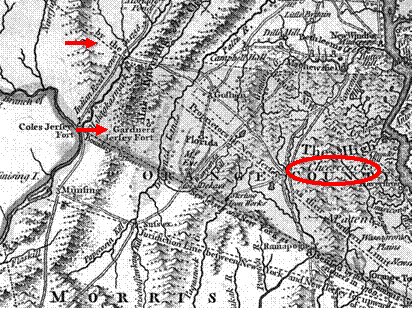
Primary Document: Colonial Era Map
|
|
(This map was drawn in 1776 from prior surveys)
|
|
|
|
|
|
 |
 |
 |
 |
 |
 |
 |
 |
 |
 |
 |
New Jersey and
New York
|
|
disagreed about
the boundary
|
|
until 1769.
|
|
|
Richard Gardner
worked for the
|
|
New Jersey claim
and tried to
|
|
enforce that
claim with local
|
|
landowners, and
much of
|
|
Warwick was
considered to be in
|
New Jersey.
|
|
|
The dispute was
settled in 1769
|
|
by the famous “Waywayanda
|
|
and Cheesecocks Patent Trial”
|
|
held in
Goshen. Opposing
|
|
attorneys were
Alexander
|
|
Hamilton and
Aaron Burr.
|
|
|
|
|
|
 |
|
|
|
|
 |
 |
 |
 |
 |
 |
 |
1.
Topography determines
|
|
|
roads.
|
|
|
2. Roads lead to settlement.
|
|
3.
As settlement continues
|
|
|
and
resources are
|
|
|
|
exploited,
disputes
|
|
|
arise.
|
|
|
|
|
|
|
|
|
Colonial
era: government, culture, preludes to war
|
|
|
|


