Colonial era: government, culture, preludes to war
Primary Document: Colonial Era
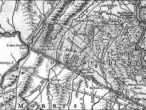
 Map
 (This map was drawn in 1776 from prior surveys)
1. Topography determines roads.
2.  Roads lead to settlement. 
3. As settlement continues and resources are exploited, disputes arise.
New Jersey and New York disagreed about the boundary until 1769.
Richard Gardner worked for the New Jersey claim and tried to enforce that claim with local landowners, and much of Warwick was considered to be in New Jersey.
The dispute was settled in 1769 by the famous “Waywayanda and Cheesecocks Patent Trial” held in Goshen.  Opposing attorneys were Alexander Hamilton and Aaron Burr.
In colonial times, the letter “s” was often printed as an “F” (look at “Goshen”)

A. The colonial government awarded land grants, or patents.
 Local Warwick land grants were:
•Samuel Staats, who built a house here in 1700 (possibly the oldest standing house in Orange County), on the grounds of what is now Applewood Orchard off Four Corners Rd.  See http://www.applewoodorchardsandwinery.com/History.htm
•Cheesecocks Patent in 1702, covered some sections of Warwick, primarily in eastern part of town.
•Wawayanda Patent in 1703 (this is the Patent signed by Benjamin Aske and Warwick’s local chief, Chuckhass)

B. The ill-defined boundaries of sometimes overlapping patents resulted in many lawsuits, the most well know of which is the Wawayanda & Cheescocks Patent Dispute, whose opposing lawyers were Alexander Hamilton and Aaron Burr.  The case was argued at Yelverton’s Inn, in Chester in 1785.

C. Stories of daily life found in “Under Old Roof Trees” (see extract handout).

D. The strategic target in Warwick that seems to have been prominent in the minds of the British was the Sterling Iron Works.